


Goldfinger
UNCONVENTIONAL PLACER DEPOSIT
MAYO MINING DISTRICT, YUKON
Location
Located 430 km north of Whitehorse, Yukon in the Mayo Mining District
Property is a 30 min drive north of the village of Mayo and 8 km from Duncan Creek.
Duncan Creek Road provides an all-season maintained road through property.


Property tenure
The Goldfinger property consists of 52 placer bench claims and 5 placer creek claims
Evolution
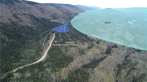
Goldfinger is a unique placer deposit associated the last ice age. High-energy meltwater flow off the margin of the glacier deposited a coarse outwash gravel. The area of coarse-gravel deposition covers approximately 300,000 square yards. Additional areas on the property need investigation and testing.


Pay Gravel
The pay gravel is located near surface with limited overburden or permafrost. Some of the best values are located adjacent to the Duncan Creek Road and overlain with 50-80 cm of sand. Pay thicknesses ranges from 0.6 to 2 metres based on current exposure. Overall gravel thicknesses are much greater and there is potential for a bulk low-grade deposit underlying the higher grade surface pay. The pay gravel is coarse and contains boulders.
2026 Exploration
A 30 cubic yard sample was processed from a channel paralleling the Duncan Creek Road. A total of 6.6 grams of gold was recovered from the test. In addition, a 2 yard test completed closer to the road and still within the channel contained 600 mg of gold. Two additional 1 yard tests were completed from a second channel paralleling the road that contained 250 mg and 340 mg respectively. That channel deposit is a minimum of 2 yards in thickness and has an undetermined length. Full testing results are available upon request.


Placer Gold
Placer gold is generally fine and flakey with pieces up to oatmeal flake in size. At this time we have no data on the gold purity, although we expect a value of 80-85% based on placer gold from nearby Duncan Creek.
Permitting
The property has a 10 year, class 4 water license and placer mining land use permit that was granted in May 2026. This is a bench-mining situation that will require water transport and recirculation. Staking to Field Creek provides an intake option. There are no wetland or heritage polygons within the core placer deposit area.

Field Creek


Mapping
Surficial mapping of the property based on LiDAR interpretation has been completed for the main areas of the property and provides valuable guidance for mine planning and future exploration.

For Sale or lease
The Goldfinger Property is ideally suited for a small to medium-size operation processing approximately 50 yards/hr, with potential to grow. The ease of access, at-surface pay gravel, and absence of permafrost are very rare qualities.
This is a fully permitted property. Bulk sampling in June, 2026 has confirmed grades ranging from 0.0071 to 0.011 raw oz/cubic yard. The sale of this property includes placer geology assistance from the owner to ensure maximum success.
For more information call Jeff Bond at: 867-335-7627 or email: jeffbondgeo@gmail.com
